- Designing an Apartment Building for Bike Commuters
Source: City Lab; September 6, 2016
Summary: A new building in Malmö, Sweden is designed for biking residents and travelers. The building has no automobile storage, but each unit comes with a subscription to a carpool service. More substantially, the doors, elevators, and balconies are designed to accommodate the extra width demanded by handlebars. The motel rooms on the first floor come with an included bike rental.
Opinion: This building represents an alternative that most American cities would be unable to accommodate because their laws cannot make onsite automobile storage optional. Local laws almost always mandate that everyone, even people who do not own cars, must pay for auto storage in their homes. This could be alleviated if we eliminated parking minimums. - Biketown bike-share launches today: Five things to know
Source: The Oregonian; July 19, 2016
Summary: One thousand orange rentable bikes hit the streets in Portland in July 2016. You sign up on a website to check them out. The community is anticipating that they'll be used pretty heavily by tourists. Speaking of heavy, they do weigh in at 45 pounds, but with lights and an upright design, they're built for safety. And, yes, the parking for the bikes did displace some auto--and bike--storage locations.
Opinion: The Columbian followed up a month later. Rentals exceeded expectations. The City is awaiting the arrival of autumn weather to see how the program is affected. Portland is a bike-friendly city, so it should be anticipated that a bike rental program would be popular for the people who choose to visit, after all, it's part of what makes Portland Portlandia. It should be interesting to see the data and what effect, if any, it has on land use patterns. - Cyclists to Drivers: This Is My Lane!
Source: City Lab; September 9, 2016
Summary: Ohio is beginning to eliminate their "Share the Road" signs in favor of "Bikes May Use Full Lane" signs.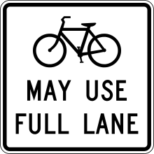 Opinion: Subtle doesn't always work. The remaining concern is that, maybe drivers will interpret that as a special condition of that section of road. These signs are standardized through the Manual on Uniform Traffic Control Devices (MUTCD), so customizing it to include the word "everywhere" would be discouraged. In Spokane's case, these signs may be appropriate along bike routes, but also in locations where the City posts the general speed limits.
 - The Real Risks in Urban Cycling
Source: City Lab; September 6, 2016
Summary: Bikes provide health benefits associated with physical activity, but there's also concerns associated with automobile crashes and bad air quality. A recent study has found, however, that in most cities, the health benefits provided by biking outweighs the risks.
Opinion: While this is likely true, the knowledge of the health benefits may not outweigh the visceral fear of having a car blast by you! Many of the benefits of biking will not be experienced by the general public until auto operators become more accustomed to the presence of bicyclists. Unfortunately, it is likely that there will still be a population that will remain hostile and aggressive, as noted in the story.
Four the Future - Urban Biking
Four stories about biking in urban areas: where to live, how to get a bike, where you can ride, and what will it do to you?


Four the Future - Transit Effects
Today: Bad transit stops, increasing transit demand, changing transit communities, and a transit public health win.
- This Tiny Roadside Refuge in Silver Spring Is Your Sorriest Bus Stop, America
Source: StreetsBlog USA; July 8, 2016
Summary: StreetsBlog USA had a tournament of "sorry" bus stops. The tournament allowed readers to vote of how bad the bus stops were. The worst is in Maryland, where the bus stop is completely inaccessible to pedestrians. There is hope, however, as there has been a request to fund a pedestrian crossing so people don't have to take their lives into their hands just to catch a ride.
Opinion: If you follow the link in the story to the Washington Post article, you'll see that it used to be even worse--probably because none of the responsible agencies would take responsibility. And, what's the effect of this kind of infrastructure? Little, except perhaps reinforcing the perception that transit is mainly for people who don't have a choice, because who, exactly, would use this bus stop if they had an alternative? - TransLink report highlights chronic overcrowding and record ridership
Source: CBC News; September 8, 2016
Summary: The transit system in Vancouver, British Columbia is experiencing overcrowding even outside of peak times. The federal and provincial governments have committed to expansion plans. TransLink is in talks with local governments to find the additional revenue needed to expand service.
Opinion: Many transit systems experienced expansions in the last decade as communities experienced a significant shift in their travel habits. The increase in demand must have a spatial effect, as transit is concentrated in specific locations. So what's the effect of high ridership? Consider the increased value of the land and buildings adjacent to places with significant transit investment, as in the next story. - Watching Los Angeles Gentrify
Source: City Lab; September 6, 2016
Summary: There appears to be a correlation between the construction of transit lines in Los Angeles and the increase in the value of the adjacent neighborhoods. In neighborhoods where transit investments were made, "residents became whiter, richer, and more educated." People with lower incomes were displaced.
Opinion: It makes perfect sense that when a service that is valued is added to a location, the location's value goes up. However, it is not correct to assume that because the location's value goes up that the people who live there can continue to afford it. I've mentioned this before and it bears repeating. Just because you make improvements in an area doesn't mean that the benefits will go to those who currently live there. Indeed, you may tear the neighborhood apart. You must be mindful of whether the benefit is designed to help the place or the people. - When Light Rail Opens, Do People Really Get More Exercise?
Source: City Lab; September 8, 2016
Summary: One of the benefits touted for transit use is that people who live near light rail stations walk more. But, it may be that the level of exercise you get is actually related to how much exercise you got before--only sedentary folks increased physical activity. Bus trips may have been replacing walking and biking trips for more active people. There is still much we must learn about how transit affects neighborhoods.
Opinion: It makes sense that one change to a person's environment may not be enough to change a person's habits all by itself. Certainly, when a person has already made a commitment to physical activity, adding transit wouldn't alter that too much. But, as the study notes, getting a sedentary population to walk more is a significant public health win. Providing focused assistance to this population might have a great effect. (Need I note that many Americans are part of this population?)
Monroe/Lincoln Construction Update
This is an update to the post a few days ago that addressed the effect of road reconstruction on business in downtown Spokane. Anyone who has driven on the Lincoln or Monroe in the last few years knows that this road needed to be reconstructed. The surface was, shall I say, bone-jarring and carries a heavy traffic load.
This reconstruction is particularly complex due to the number of utilities and vaults under the right-of-way. Fortunately, the City made the decision to replace all of the infrastructure at the same time. This situation would be worse if the road had to be "opened up" several times rather than just once because road construction does reduce access to the adjacent businesses.
There is some concern that the construction won't be completed by the end of this construction season, which would mean that the road would be patched up to winter over, then they'd finish the work next year. City Council President Ben Stuckart asked public works to address the concerns, and the council was told that there was a delay in the bidding process because of a delay in federal approval. In an attempt to get the project back on schedule, overtime hours had been paid and there would be more if there was an indication that it would help.
In the meantime, the City has announced that paving will begin on September 17. Work will continue into November.
Some business associations are working together to try to help out the restaurants. While I'm sure the effort is appreciated, the benefit of the partnership between a couple of organizations that normally work together will not bring a huge impact all by itself. The impact comes from the announcement of the partnership in order to get media time. The real way these businesses benefit is if you, too, band together with your friends and business partners and visit the affected restaurants. Yes, you'll have to cross near some open streets, but there's no danger. You just need to make a little effort.
This reconstruction is particularly complex due to the number of utilities and vaults under the right-of-way. Fortunately, the City made the decision to replace all of the infrastructure at the same time. This situation would be worse if the road had to be "opened up" several times rather than just once because road construction does reduce access to the adjacent businesses.
There is some concern that the construction won't be completed by the end of this construction season, which would mean that the road would be patched up to winter over, then they'd finish the work next year. City Council President Ben Stuckart asked public works to address the concerns, and the council was told that there was a delay in the bidding process because of a delay in federal approval. In an attempt to get the project back on schedule, overtime hours had been paid and there would be more if there was an indication that it would help.
In the meantime, the City has announced that paving will begin on September 17. Work will continue into November.
Some business associations are working together to try to help out the restaurants. While I'm sure the effort is appreciated, the benefit of the partnership between a couple of organizations that normally work together will not bring a huge impact all by itself. The impact comes from the announcement of the partnership in order to get media time. The real way these businesses benefit is if you, too, band together with your friends and business partners and visit the affected restaurants. Yes, you'll have to cross near some open streets, but there's no danger. You just need to make a little effort.
Four the Future - Oil and Methane
Today, methane sector air pollution is increasing, a massive methane leak is finally capped, there's limited information on oil train bridges, but some first responders are receiving new information in Washington.
- Air Pollution from Natural Gas Industry in Pennsylvania on the Rise
Source: Planetizen; August 27, 2016
Summary: As methane (natural gas) production increases, so does the amount of pollution this sector of the energy industry creates. This includes sulfur dioxide and volatile organic compounds (VOCs). However, this is more than balanced out by improvements in emissions by the switch to natural gas from coal.
Opinion: I've addressed fracking in the Marcellus Shale in the past. Lately, the EPA is moving to tighten methane emissions standards in the oil sector, where methane emission is a byproduct of oil production. There has been increased interest in regulation of fuel production at more than just the federal level.... - New oil train rule will give emergency responders advance notice of shipments
Source: Spokesman-Review; August 26, 2016
Summary: Beginning in October, the State of Washington's emergency responders will receive notice of crude oil shipments through their communities.
Opinion: Ecology's has set up a webpage concerning the new rule on the Oil Movement by Rail and Pipeline Notification web page. It is critical for public safety that the first responders have the information they need to manage an emergency situation. - California Declares State Of Emergency Over Months-Long Gas Leak
Source: National Public Radio; January 7, 2016
Summary: Methane was leaking in Southern California for months by the time of this article (which includes an audio story and video of the leak). The leak was originally detected on October 23, 2015. The operator stated that they finally stopped the leak on February 11, 2016.
Opinion: Methane is an odorless, colorless gas, but the article contains great video of what the leak actually looks like through an infrared camera. People had been driven from their homes due to the odor (the hydrogen sulfide added by utility companies) and cases of nausea. - Railroads keep most bridge inspection data secret
Source: Spokesman-Review; September 5, 2016
Summary: Federal law requires that railroads provide information on their bridges to local governments, but the information provided is limited. The bridges are inspected by the railroads based on the railroads "strong financial incentives" to keep them functional. Some of the bridges look unsafe, but what the bridges look like isn't important, just whether the bridge is safe or not.
Opinion: While it's probably true that the bridges' appearance isn't telling, the fact that the railroads won't explain how they are evaluating the bridges is telling. These organizations are dismissive of the public. They believe they're above examination. After events like the recent oil train derailment in Mosier, Oregon, they're going to find that the harder they resist input from the public, the harder the push back will be. They're almost guaranteeing that the hammer will come down harder on them in the end.
Climbing the Participation Ladder
I am told by my father that I saw the launch of Apollo 11 and watched as Neil Armstrong stepped on the moon a few days later. I'm sorry to say that I don't have a memory of it because I was a 19-month old. Nevertheless, I still use the moon landing as a moment that helps many people get a sense of how long it has been since other events of its time.
In the same month that humans first stepped on the face of the moon, an article was published in the Journal of the American Institute of Planners entitled "A Ladder of Citizen Participation." Written by Sherry R. Arnstein, it proposes that there are different levels of citizen participation. Inasmuch as different public participation techniques are employed, citizens have power and influence over the outcomes of governmental activities.
When the public sector does not satisfy your needs, remember that the private sector and the non-profit (or Non-Governmental Organization/NGO) sectors are still there. Rallying business interests, provided your interests coincide with yours, can be helpful in making sure that your voices are heard. Also, simple neighborhood action without the formal structure of an organization, is part of your American freedom.
Take, for instance, the case of the trees on Bernard Street on Spokane's South Hill. The City had signed the death warrant on a number of trees because they were in the way of a street improvement. The neighborhood objected and, while some plans were changed to accommodate some of the concerns (saving six of the 23 trees was called a reasonable balance), the community expected to be empowered to save those trees based on their interpretation of the city's comprehensive plan.
The neighbors in the community rallied and, in the end, changed city government: they were instrumental in ousting the mayor, and installed one of their own on the city council. This time, when Lincoln Street was reconstructed, the neighborhood had more input and there wasn't the uproar that only a few blocks and a few years away had experienced.
It goes without saying that there is a tendency, even in a old republic such as America, for those in power to retain as much authority as they think they can reasonably (or unreasonably) hold. It's not entirely unreasonable for powerholders to state that they have been duly elected and thereby have the responsibility to make decisions on behalf of the electorate. However, even in the best democracies, a small group of people cannot fully represent the vast opinions and experiences of the populace. Additionally, there are times when the powerholders' claim of authority exceeds their actual level of concern. The result is always a tragedy when a decision maker cannot legitimately claim to care about the outcome enough to pursue the optimal solution, yet decides nevertheless.
Let's not also claim that the public always has the best intentions, however. The public must be restrained in matters of people's rights. We can still see the tendency for an officially secular and egalitarian nation (like the United States) to host manifestly discriminatory people whose wont is to harm others through official means. In this case, it's entirely appropriate for powerholders to put boundaries on citizen power, and I would argue that can be a primary role for them. Unfortunately, taking such a stand can often interfere with their personal need to remain a powerholder. It's not uncommon enough for powerholders to prey upon people's biases and use the promise of institutional discrimination to gain votes.
And while the powerholders may harness the power of rockets to put men on the moon, they can't always seem to empower the very people who authorized the government to exist in the first place. But, unfortunately, that's exactly what some of them intend. It's up to you, as planners and as citizens, to prevent that from happening.
In the same month that humans first stepped on the face of the moon, an article was published in the Journal of the American Institute of Planners entitled "A Ladder of Citizen Participation." Written by Sherry R. Arnstein, it proposes that there are different levels of citizen participation. Inasmuch as different public participation techniques are employed, citizens have power and influence over the outcomes of governmental activities.
Rungs of the Ladder
The ladder, as depicted in the article, has eight rungs. Arnstein states that, in truth, "there might be 150 rungs with less sharp and 'pure' distinctions among them." The point is that there are different levels of public participation in public decision making. The rungs she chose are (from bottom to top):- Manipulation
- Therapy
- Informing
- Consultation
- Placation
- Partnership
- Delegated Power
- Citizen Control
Taking the Stairs
When the government does not live up to your expectations, there is the feeling that there's nothing to be done. "You can't fight city hall," they say. But, there is an alternative. If the government doesn't let you take the ladder, take the stairs. Resolve not to be trapped by their designed limits.When the public sector does not satisfy your needs, remember that the private sector and the non-profit (or Non-Governmental Organization/NGO) sectors are still there. Rallying business interests, provided your interests coincide with yours, can be helpful in making sure that your voices are heard. Also, simple neighborhood action without the formal structure of an organization, is part of your American freedom.
Take, for instance, the case of the trees on Bernard Street on Spokane's South Hill. The City had signed the death warrant on a number of trees because they were in the way of a street improvement. The neighborhood objected and, while some plans were changed to accommodate some of the concerns (saving six of the 23 trees was called a reasonable balance), the community expected to be empowered to save those trees based on their interpretation of the city's comprehensive plan.
The neighbors in the community rallied and, in the end, changed city government: they were instrumental in ousting the mayor, and installed one of their own on the city council. This time, when Lincoln Street was reconstructed, the neighborhood had more input and there wasn't the uproar that only a few blocks and a few years away had experienced.
Thoughts
You can tell much about a community by their default level of citizen participation. And, it's not just a matter of whether people participate or not, but also what they've been taught to expect and what the government offers as a conduit for public opinion into their processes.It goes without saying that there is a tendency, even in a old republic such as America, for those in power to retain as much authority as they think they can reasonably (or unreasonably) hold. It's not entirely unreasonable for powerholders to state that they have been duly elected and thereby have the responsibility to make decisions on behalf of the electorate. However, even in the best democracies, a small group of people cannot fully represent the vast opinions and experiences of the populace. Additionally, there are times when the powerholders' claim of authority exceeds their actual level of concern. The result is always a tragedy when a decision maker cannot legitimately claim to care about the outcome enough to pursue the optimal solution, yet decides nevertheless.
Let's not also claim that the public always has the best intentions, however. The public must be restrained in matters of people's rights. We can still see the tendency for an officially secular and egalitarian nation (like the United States) to host manifestly discriminatory people whose wont is to harm others through official means. In this case, it's entirely appropriate for powerholders to put boundaries on citizen power, and I would argue that can be a primary role for them. Unfortunately, taking such a stand can often interfere with their personal need to remain a powerholder. It's not uncommon enough for powerholders to prey upon people's biases and use the promise of institutional discrimination to gain votes.
And while the powerholders may harness the power of rockets to put men on the moon, they can't always seem to empower the very people who authorized the government to exist in the first place. But, unfortunately, that's exactly what some of them intend. It's up to you, as planners and as citizens, to prevent that from happening.
Making the walk walkable
A few summers back, I was an unpaid intern at the City of Spokane. The fact that I was unpaid is not of great concern to me (it did, in the end, work out quite handsomely for me) but, it did provide me with a specific motivation: attempt to avoid any costs whatsoever in the performance of my work. I labored on a number of projects while I was there, and I could regale you with stories about federal grant application or the design of local economic development strategies, but this post is more pedestrian.
I'm fond of saying that the purpose of transportation systems is to bring your destination within walking distance. While that is useful in pointing out that no car, bus, train, bike or other transportation mode is necessary if you're within walking distance, it also raises the question, "what is walking distance?" This is an important question because the design of effective walkable districts is dependent on understanding the willingness and capability of pedestrians to utilize it.
While different pedestrians have variations in ability, I'm not going to dwell on that issue for this particular entry. However, I will briefly state that the Americans with Disabilities Act (ADA) has the potential to greatly enhance the ability of people to have access to the world around them without significantly disadvantaging anyone. The minimal costs associated with ADA compliance is trivial compared to the sums lavished on roads and highways. Whenever I say "pedestrian" in this entry, please remember that it's not just people in sneakers, but also people in chairs and with strollers and other devices who use many of these same facilities and deserve the same level of access.
Making it Walkable
Pedestrians need more than a strip of concrete to make the walk walkable. Yes, the distance is key and that implies density. Ultimately, density is determined by the private sector in response to travel patterns and availability of investment. However, there are public decisions which can greatly enhance the walk, and perhaps influence private decision-making.
Shortcuts. One of the reasons we use vehicles for travel is to make ourselves less sensitive to the distances involved. It stands to reason, then, that pedestrians are less likely to walk if they have to go far out of their way to reach their destination. For my internship, I took a shortcut through a park. Pedestrians are more flexible with their courses than cars because it takes far less space and infrastructure to support a pedestrian route than it does for an automobile route. Creating shortcuts can provide great advantages for relatively small costs.
Plenty of destinations. Just because a person is busy walking to a final destination doesn't mean that the final destination is the only destination! Having the ability to combine trips is a powerful incentive to coax reticent walkers to ditch their cars. You may expect that I would introduce you to several studies which emphasize this point, but rather than do that, I will just mention one thing: shopping malls. The entire theory behind shopping malls is the power of combining trips, and the success of a well-managed mall is a testament to this concept.
Presumptive signalling. I can't emphasize this enough: waiting for a cross signal greatly slows an already slow travel method, and requiring a pedestrian to push a button mandates the wait. The signals should be set to allow enough time for a pedestrian to cross without prompting from pressing a button, thereby eliminating the need for the button. If the light changes automatically for automobiles, then the signal should allow a pedestrian to cross as well. If the signal isn't normally long enough for a pedestrian to cross then the signal may cycling too quickly or the cross street may need to go on a diet.
Alternatives. If there are multiple routes to a destination, then no single barrier or hazard can prevent the trip from occurring. Having alternatives also goes especially well with presumptive signalling by allowing the pedestrian to take advantage of the cross signal no matter which one is active. It also provides a greater opportunity to engage an interactive, varying environment.
Interactive environment. Pedestrians experience their environment in much greater detail than auto drivers. This not only gives the adjacent property owners an excellent opportunity to interact with the pedestrians, but it also levies a minor obligation as well. If a walking area is boring, then the pedestrian will avoid it for more interesting areas. And when people aren't attracted to a place and occupy it, then a place may not maintain a positive reputation.
Safety, cleanliness. This is fundamental: the trip must be reliably safe. Unclear sidewalks, overhanging branches, uneven surfaces, and anything that reduces the visibility of pedestrians in an auto-dominated environment are serious barriers to pedestrian activity. Cleanliness is a standard by which the safety of a path is judged, so walkways must also be well maintained.
Refuges. Providing pedestrian amenities to manage the effects of fatigue and weather are useful as well. Awnings, besides being useful for site identification, are attractive for pedestrians who wish to avoid sun or rain. Benches provide an opportunity to rest and interact. There is also the technical pedestrian refuge: a space in the median of a road where a pedestrian can stop so they only have to cross half the traffic at one time.
Human services. In addition to managing the negatives of pedestrian activity, it's helpful to have some services available to be provided directly to the pedestrian, such as meals, coffee, etc. Not only does this enhance an area for the pedestrians, it also provides people with an excuse to become pedestrians for the adjacent properties. One of the first thing we noticed as students surveying Sprague Avenue in the University District was that there's the smell of coffee from a local roaster, but no coffee retail. Without this amenity, there's really no way for people to gather and produce a community.
Friendliness. And another part of making that community is having a culture that appreciates the presence of other people. I was struck one morning, heading to City Hall, by the great attitude of another downtown employee. He was wearing a "Cruisers" (a local burger joint) shirt, asking how I was doing that day. We weren't at his place of work--he was just being friendly to a fellow pedestrian. When I told him that I was impressed he said he was "just making Spokane a great place!" True.
Four the Future - Reconfiguring Roads
A look at the issues surrounding road reconfiguration: the redesign on Spokane's Community Block, an adjacent neighborhood's opposition to a pedestrian mall proposal, the massively positive effect of roads on retail activity, and a peek in on a little-used alternative.
- Getting There: West Main to get new kind of street parking
Source: Spokesman-Review; September 5, 2016
Summary: Main Avenue between Division and Browne will be reconfigured to add additional parking and pedestrian amenities. The street will be reduced to two lanes in order to accommodate a third lane of parking in the median, a mid-block crossing for pedestrians with channeling structures that create pedestrian havens, and pedestrian-scale lighting. Local business owners are in favor of the new design.
Opinion: The new design is highly supportive of the activities on the block in question. It will take some time for drivers to adjust to the new configuration, particularly since traffic speeds is likely to reduce. And, of course, there will be the routine scoffing from the peanut gallery (as always, it's important to remember not to enter the cesspool that is the comments section of the Spokesman-Review website). However, with greater parking and pedestrian support, the retailers should benefit. - Rose Pak flashes red light on Stockton Street pedestrian mall
Source: San Francisco Chronicle; August 7, 2016
Summary: When San Francisco tore up Stockton Street to install a subway, the businesses of the Union Square Business Improvement District suffered sales losses (this is a misinterpretation of the data; more on that below). The solution was provide the retailers with a pedestrian area with artificial turf (here is a photo on the installation, provided by the San Francisco Metropolitan Transportation Agency):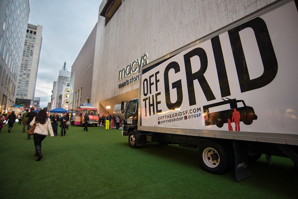
This sparked the idea of making a permanent pedestrian mall. However, the adjacent neighborhood is registering an objection because they want the road to be available to bring traffic to their businesses.
Opinion: This demonstrates a fundamental issue in transportation planing in the United States: for whom is the right-of-way designed? The reason why we have this problem is that Americans tend not to differentiate between roads (which are used to increase mobility and provide a path through a place) and streets (which are used to increase access and provide a path to a place. Instead, we design and construct stroads, which do neither task particularly well, and are dangerous to boot. We know instinctively that we do this incorrectly: just think of the number of times you've complained about people driving too fast through your neighborhood. People drive fast on roads and buy things (and live) on streets. Planners need to get property owners to collaborate on what their right-of-way is intended to achieve, and transportation engineers must design to those purposes. - Getting There: Downtown Spokane businesses suffer in construction zones
Source: Spokesman-Review; August 15, 2016
Summary: Businesses adjacent to construction projects in Spokane depend on revenues from people to travel to their locations. But, when construction occurs, customer visits drop (in one case, by half) imperiling the business. Other businesses are less affected because they have a dedicated customer base. Extending construction hours to reduce the length of time isn't effective because it would cost more and the work is job is hard on the workers.
Opinion:Americans are strongly driven by convenience. If the journey to your door isn't convenient, it just isn't taken. Unless you're an anchor (or "destination") retailer, ease of access is key--and that's exactly what government-maintained right-of-ways are providing. I humbly suggest that, rather than take this story as a tale of woe about construction barriers, please view this as a testimonial as to the effectiveness of the roads all the other summers when construction isn't at your doorstep. Yes, it hurts this year, and help would be beneficial, but remember that the road doubles your sales all other years.
This story has been updated. - Omaha's answer to pothole complaints: a new dirt road
Source: Associated Press; August 16, 2016
Summary: To the chagrin of its residents, the City of Omaha is removing pavement in certain neighborhoods. All cities have a long list of deferred road replacement projects, but Omaha is characterized by extreme sprawl. Making short-term deals in order to encourage development results in these long-term deficiencies.
Opinion: The chickens come home to roost. Of course, the initial developers want to avoid costs in order to make their developments more profitable and avoiding building to City standards is one way to do that. Of course, that means that the neighborhood has a responsibility to maintain the road, but they rarely do because, again, they're trying to avoid paying for what they're using. I hasten to add, though, that we shouldn't dismiss the possibility that the City demands that everyone have a stroad in front of their house rather than a street! Regardless, the costs of periodic repavement is substantial, and many people are satisfied with letting some (read: someone else's) neighborhoods degrade. It's high time that the federal and state governments deny funding for and authority to accept new road construction without demonstrating that they have the funds available to properly maintain their road infrastructure.
What is Sprawl?
I was reading a recent article on The Atlantic Cities entitled High Density Sprawl is Still Sprawl. It got me thinking about what sprawl actually is. While I agree with some of the observations the article makes, I'd prefer to have a definition of sprawl which is less gut-felt.
Sprawl is also not entirely about walkability. I spent my junior high and high school years in the town of Odessa, Washington. Everything in town was within walking distance, what little there was. As an agricultural town, the variety of services available was limited, and no one would say that it was urban. If Odessa were magically transported to the edge of an urbanized area there is little doubt that it would be considered sprawl. However, in its current location it is entirely appropriate and necessary.
Sprawl is also not entirely about suitability. In the article referenced above, the author objects to agricultural activities in a place where he believes water was unavailable or available using inappropriate means. In effect, he is stating that the location is unsuitable for the activity. My observation on this particular example is that the context is missing: what effect does utilizing aquifer water at this location have on other activities, human or not? Perhaps it has a beneficial effect — we have no way of knowing. Nevertheless, suitability cannot be a sole determinant of whether an activity is sprawl, as few would argue that large agricultural tracts immediately adjacent to a high density core and surrounded by low density housing tracts would not be eligible for infill, even if it were of high soil quality. Suitability is an important factor in determining appropriate uses, but it's not determinative.
A high density residential subdivision on the edge of an urban area may be internally walkable, the land may be suitable for that purpose, but its lack of quality relationships with its surroundings gives us pause. (It is likely better, however, than the same number of units spread over a much larger area!) A centrally located large tract agricultural activity may be highly suitable for its particular soil conditions, but it severs the bonds between the core and those it serves. Sprawl, then, is not about the characteristics of the individual use, but about the uses’ context and relationship with surrounding uses.
In attempting to characterize sprawl, we should think in terms of a spectrum – some places are more or less sprawl-like – determined largely on each uses' ability to interact with other uses. A residence may be sprawl in one location and not in another based on its ability to facilitate interaction amongst other residents, commercial and retail areas, and third spaces. Likewise, the presence of a residence alters the degree of sprawl experienced by adjacent parcels.
Sprawl is avoided, then, by ensuring a mix of positively interactive uses. (It is important to note that negative interactions do exist and should be minimized. Zoning was intended to separate incompatible uses; it has been well argued that it has gone too far.) It is easy to see how density would contribute to the number of interactions available to a location, as would walkability. Suitability can be integrated into our understanding of sprawl by including the positive or negative interactions between the use and the natural services provided at the location, and the interactions caused by all externalities.
But why do we even care about that? If both areas function, then what is the issue? Economics is not a gentle mistress. Inefficiencies built into our land-use patterns weigh upon economic development initiatives, and the region’s earning potential suffers. Increasing hostility in our politics indicates that our culture is beginning to devalue the ability to interact civilly with other people, potentially due to a reduction in opportunities to practice interacting civilly with other people face-to-face. One might say we are suffering from a breakdown of positive interactions in several ways, and we should care about these things for both cash and culture.
Just one final thing: let us remember that the correction of sprawl is not an end in itself. Sprawl is merely a way of measuring the net positive interaction of site within its context. It is an abstract concept, created to measure the relative dysfunctionality of a location. It cannot diagnose the cause of the problem, but merely the presence of one. The solution must remain in the hands of those who are disadvantaged by it, and those it will harm in the future.
What it is not
First, let's start with the things that sprawl is not. It is clear that sprawl is not entirely about density. If it were, then sprawl would not need to be a separate concept – we would only speak in terms of density. It's more complicated than that. When the author notes that high residential densities at the edge of an urban region constitutes sprawl, I believe he is mostly correct, but there important details that are missing from the analysis.Sprawl is also not entirely about walkability. I spent my junior high and high school years in the town of Odessa, Washington. Everything in town was within walking distance, what little there was. As an agricultural town, the variety of services available was limited, and no one would say that it was urban. If Odessa were magically transported to the edge of an urbanized area there is little doubt that it would be considered sprawl. However, in its current location it is entirely appropriate and necessary.
Sprawl is also not entirely about suitability. In the article referenced above, the author objects to agricultural activities in a place where he believes water was unavailable or available using inappropriate means. In effect, he is stating that the location is unsuitable for the activity. My observation on this particular example is that the context is missing: what effect does utilizing aquifer water at this location have on other activities, human or not? Perhaps it has a beneficial effect — we have no way of knowing. Nevertheless, suitability cannot be a sole determinant of whether an activity is sprawl, as few would argue that large agricultural tracts immediately adjacent to a high density core and surrounded by low density housing tracts would not be eligible for infill, even if it were of high soil quality. Suitability is an important factor in determining appropriate uses, but it's not determinative.
Interrelationships
Like many other things in planning, it's not merely a single concept which tells us about how the neighborhood works. Yes, the characteristics of sprawl are related to density, walkability, and suitability. However, the interrelationships between various elements of a neighborhood – how it works in a practical sense – determines the health and functionality of the place. If the concept of sprawl is to be useful, it must also contain these interrelationships.A high density residential subdivision on the edge of an urban area may be internally walkable, the land may be suitable for that purpose, but its lack of quality relationships with its surroundings gives us pause. (It is likely better, however, than the same number of units spread over a much larger area!) A centrally located large tract agricultural activity may be highly suitable for its particular soil conditions, but it severs the bonds between the core and those it serves. Sprawl, then, is not about the characteristics of the individual use, but about the uses’ context and relationship with surrounding uses.
In attempting to characterize sprawl, we should think in terms of a spectrum – some places are more or less sprawl-like – determined largely on each uses' ability to interact with other uses. A residence may be sprawl in one location and not in another based on its ability to facilitate interaction amongst other residents, commercial and retail areas, and third spaces. Likewise, the presence of a residence alters the degree of sprawl experienced by adjacent parcels.
Sprawl is avoided, then, by ensuring a mix of positively interactive uses. (It is important to note that negative interactions do exist and should be minimized. Zoning was intended to separate incompatible uses; it has been well argued that it has gone too far.) It is easy to see how density would contribute to the number of interactions available to a location, as would walkability. Suitability can be integrated into our understanding of sprawl by including the positive or negative interactions between the use and the natural services provided at the location, and the interactions caused by all externalities.
The Uses of 'Sprawl'
We here in Spokane have, for a very long time, recognized that the lack of middle income housing in downtown Spokane is a problem. In a way, it's the same problem that we have with large residential subdivisions that lack commercial activities. Both areas exhibit the same weakness; both areas show signs of sprawl.But why do we even care about that? If both areas function, then what is the issue? Economics is not a gentle mistress. Inefficiencies built into our land-use patterns weigh upon economic development initiatives, and the region’s earning potential suffers. Increasing hostility in our politics indicates that our culture is beginning to devalue the ability to interact civilly with other people, potentially due to a reduction in opportunities to practice interacting civilly with other people face-to-face. One might say we are suffering from a breakdown of positive interactions in several ways, and we should care about these things for both cash and culture.
Just one final thing: let us remember that the correction of sprawl is not an end in itself. Sprawl is merely a way of measuring the net positive interaction of site within its context. It is an abstract concept, created to measure the relative dysfunctionality of a location. It cannot diagnose the cause of the problem, but merely the presence of one. The solution must remain in the hands of those who are disadvantaged by it, and those it will harm in the future.
Cascade Collaborative: A Planners Conference
For the next three days, the Washington and Oregon Chapters of the American Planning Association are meeting in Portland, Oregon for their annual conferences. But, rather than operate separate events, they are working together on one which will serve the needs of both organization's members.
Today's events include mobile workshops, discussions about topics while traveling to sites to show planners how the topic affects what happens on the ground, in the world. While there are several mobile workshops underway, this blog will address two: Portland's Food Carts, and the Beaverton's EcoDistrict. Entries will be linked from here when they become available.
Over the next couple days, there will be numerous other entries, and they will be linked from here as well.
Q&A with the Deal Makers
Moderator:
Denice Trimble, GordonDerr
Speakers:
Denice Trimble, Partner, GordonDerr
Seth Hudson, Weston Solutions Inc
Don Moody, First Vice President, CB Richard Ellis
Ed Morales, Environmental Risk Officer, Sterling Savings Bank
10:15 AM: Denice Trimble introduced this session as an opportunity to talk about what financial resources are available for brownfield projects, and the legal and risk concerns on these projects.
How do the current economic conditions affect the negotiations these days?
Don Moody: brownfields are very similar in process to other properties, but with the inclusion of costs associated with the remediation. But, there are simply fewer buyers. Since 2007, there was a 70% decline in large lot sales. Same for brownfields. But, activity if picking up. Brownfields are becoming more positive because they tend to be in urban settings. Tearing down a building have costs, too.
Seth Hudson: They do 6-8 deals across the country for brownfield purchase and development. There has to be a trust relationship and a exit strategy. They do not hold property for more than 5 years. They clean them up and move on. This is easier with access to capital.
How has the economy affected the financing of brownfields?
Ed Morales: There haven't been many deals lately, as developers have been licking their wounds on construction loans. But, there is money available. It's important to try to understand the risk. U.S. Bank wants to do these kinds of loans because they have internal expertise. Private investment brownfield "flippers" are saying that there are places where brownfields are ready to be taken up, and the Northwest is one of the hot areas, particularly Seattle and Bellevue.
Hudson: Agreement on that last point.
How do you identify the right properties?Moody: There is movement away from greenfield development. From a financing perspective, owner may have to finance half the cost. But, sometimes, there's no point to insuring a building, except for liability, because it doesn't matter if it burns down. But sometimes they can be used for purposes which provide low incomes. In the end, though, it's important to have good exit strategies.
Hudson: It used to be that if you build it, they will come, so it's little more than buying it, cleaning it up, then selling it to someone. The market is changing because you can identify a customer first and find a property that best fits their needs. Now they can set criteria for site selection because they know a specific need. That's what has changed the most. But, sometimes, current owners call to dispose of it.
Moody: It's almost impossible to find financing for a new building right now, even if the need can't be met elsewhere. That's new. So, it may be that they must use a brownfield site because it doesn't exist any other way.
Hudson: There are finance structures which recognize that the land might be upside down prior to the environmental concern. In that case, property owners might provide the land for free (even with cash) to get it off their books. Alternatively, the payment for the sale might happen on the back end after the final owner receives it.
Morales: Indemnity flow is important: who is ultimately responsible for the cost. This will also be a variable in the financial and insurance arrangements.
Moody: You must be highly curious to make these work. Every deal is different.
Hudson: people involved must be open about the situation. Testing in areas where there wouldn't be an issue isn't appropriate.
What kinds of clients are you looking for? How many are there?
Moody: there are very few buyers. there are no 30-60 day sales. These can take 3-5 years, and you don't get paid until the back end. Sales are always a team effort, including sellers, buyers, and government agencies.
From a lending perspective, what are you expecting to see during the due dilligence phase?
Morales: Do as much as possible. You're risking capital. The amount of due diligence is very important. Characterization of the site is key, and how much has been done to mitigate, and what plans are in place to complete it, including the costs. Regulators require a course of action. Insurance may cover those costs of the presumptive solution. How often does this happen? On occassion.
Hudson: this is a costly, time-consuming process. Sometimes gaining that time requires hard or soft money to hold it off the market. Sometimes a government can assist on those costs, if they're important sites. Remediation can take a year or two.
Does the size of the site matter? Are small ones worth it?
Moody: There are hundreds of small sites in Tacoma. Almost every gas station is simply too small. Aggregating them makes more sense. In old cities like that it's even difficult to determine what the source is because the contamination plumes can overlap.
Hudson: the best use for fomer gas stations are...gas stations. But there are also similarly sized uses, such as fast food drive through restaurants, so there's some possibility of that if the city will allow it. A gas station in Fresno is different from one in Beverly Hills because it has to do with land value. You can do more with it if the land value is higher.
Morales: one of the ways to make the credit people in the banks happy is to provide an insurance policy against the cost of remediation of these small sites.
Can the insurance policy actually solve the problem if there's a new owner afterwards?The term of the insurance policy is usually pretty short because there's usually enough time for big oil to finish cleaning it up within a couple years. So, it may not be necessary for later owners. But, they could also add a new beneficiary to the existing insurance policy.
Moody: It's important for brownfield experts to be a source of information for the clients so they can learn about what is actually going on here. Others may not be willing or able to provide useful information.
Hudson: For his company, the land is owned by an LLC created for that purpose, and the insurance is transferred to the corporate parent. This allows them to bankrupt the LLC while protecting the corporate bottom line.
Morales: This also helps with funding because the banks are more willing to provide dollars to the guarantor: in this case, not the LLC, but the mother corporation, which balances the risk load.
Hudson: And they provide a guarantee that if any further contamination is found, they will go back to finish it up.
How do attorneys affect this process?Trimble: This is a partnership amongst all the members of the transaction. But, yes, as attorneys are very risk averse. There is a spectrum: "as is" to "full indemnities" (though that never happens). there has to be sufficient time for due diligence. What are the representations and warranties? What is the source of the information? Some information is more reliable. There may be a limit to the indemnification. Are there sunset provisions which provides a number of years before the seller is off the hook?
Morales: the strength of the legal team is very important. Good representation makes a difference. The context is also important because there may be superfund exposure and interaction with environmental assets off site.
Hudson: But, it's important that the business terms are clear before you bring in the attorney otherwise it will never get off the dime
Trimble: Non-binding terms!
Mr. Hudson, do you work with the public sector?
Hudson: Yes.
How long are you willing to hold the properties?
Hudson: 5 years was what was said in the past. Now it's more like 5-7 years. We don't want to clean for one year then hold it for several more years. We are looking for jobs that would take longer now because there's the time. In hot markets, you have to move faster, and that's difficult with brownfields because they simply take time.
What about brownfields without a building?
Morales: There isn't alot of that going on right now because you need to know that the building was substantially leased. It was 50%, but now more like 70%.
Hudson: this requires pre-leases, even. They moved into a building they were building in order to have the building leased.
Moody: There is little market for this. It's simply not happening right now. It will take a year to get the funding and you will have to prove you don't need it to get it.
Morales: Confirmed. That's the current conditions.
What about land banking?
Morales: Yes, you can get liability insurance for a longer term after remediation. There's only three markets, though, for environmental remediation coverage, down from five last year. It's easier to do this if you're bigger. One-offs are far more difficult.
Hudson: insurance is flexible, you may put in large deductables or insurance for a part, then no insurer liability for a range of values, say between $5 million and $10 million where the company is self-insured, then the insurance kicks in again above that.
Denise Trimble thanked the participants.
A Developer's Perspective
9:09 AM: Presentation by Jason Wheaton, President, Greenstone Corporation
9:11 AM: Jason came from California, which he likes, but this area is paradise. They consider themselves as a communication company rather than a developer. When things go wrong it may be because they failed to communicate well with their internal and external customers. They tell themselves that 30% of everything they're doing is wrong. It's a hard thing to say. If you have the attitude that 30% of what you're doing is wrong, you can always get better. 30% of environmental regulations can be better, too.
9:15 AM: Market Conditions...job growth and interest rates will be the driving force in the recovery. With efforts to reduce the deficit loom, the effect on local and regional governments should be monitored. Vacancy rates are leveling off. There are opportunities, and there is some optimism.
9:17 AM: Housing inventory is beginning to be depleted. California still has a great deal of inventory. We're in a better situation. But, our market is fragile. They closely monitor the Spokane MLS Quintile Analysis. Greenstone tries to serve the middle three quintiles. There's little margin at that level for brownfield remediation.
9:21 AM: Spokane is a relatively affordable market for nice housing. The community is "tremendously appealing." With the medical base, there's good economic prospects. There are existing opportunities as demographics change. The current housing mix isn't good for our future demographics. "Investment Capital is very difficult to attract." Money is currently going to markets which were hardest hit. Spokane isn't in that category.
9:25 AM: Greenstone has adjusted to the new market, bringing down their labor force by 25%. "Hope is not a strategy." Buyers are purchasing homes for shelter, not investment.
9:26 AM: How does out region manage growth. Greenstone is pursuing a "Sustainable Growth Model." "We need strong urban growth in the next 20 years." The baby boomers are aging and are looking for a different kind of lifestyle. Empty nesters will increase by 244%. "This will be a huge burden on our government."
9:29 AM: We spend about 32% of our income on housing, and 17% on car ownership. That's 49%. If we can develop lands to reduce auto dependency, then more can go to housing and less to cars. "Shelter isn't going to be less expensive." Health care is getting more expensive. What's happening is that discretionary expenses are going away: entertainment, clothing, household furnishing, education, pensions and social security contributions. It's an attack on what made the middle class feel prosperous.
9:35 AM: Municipal infrastructure is crumbling, and it will be expensive to repair. $21.8 billion annual need for over 20 years just for transit. $131.7 billion and $9.4 billion annually for deficient roads and bridges. Water will be $151 and wastewater will be $390 billion.
9:37 AM: Only 10% of the growth is occurring in the areas which are designated as centers and corridors. Development is happening in the wrong places. There are several incentives to encourage development in the right places, but it's not happening. The brownfields in Spokane are so intense, the original map was impossible to read. There are significant areas which cannot be utilized because of this. You can follow the rail line through town on the brownfields map.
9:39 AM: Jason recommends very strongly the Department of Ecology's "Guide to Leveraging Brownfield Redevelopment for Community Revitalization." (Publication number 10-09-054.) He read the full first page of the document.
9:41 AM: There are benefits to brownfield development: creating jobs, leveraging existing infrastructure, neighborhood revitalization, new local revenue and taxes, clean up environmental problems, reduce urban decay. "Neighborhoods are always getting better or getting worse."
9:43 AM: Developers need information about the land in order to create economic certainty. Financial institutions resist investment due to "perceived long term liability and marketability issues." Brownfields depress land values, this prevents investment for remediation, so it perpetuates the problem. Most of the brownfield projects are downtown because land values are higher. This is highly inelastic, small price changes eliminates the ability to build. Worse, it affects adjacent properties' value that discourages continued investment.
9:48 AM: A review of Kendall Yards and its changing ownership. Had to leave to prepare for next section, entitled Q&A with the Deal Makers.
Welcoming Remarks
8:45 AM: Melissa Wittstruck introduced Mayor Mary Verner. Mayor Verner is thanking people for attending and encouraging the participants to see how Spokane has changed over the years.
8:50 AM: Mayor Verner is reflecting upon how Riverfront Park used to be a brownfield site, contaminated by the presence of the rail yards. University District is also a brownfield site with its remediation currently underway.
8:56 AM: Mayor Verner continues: There will be a tour tomorrow which will include many sites around Spokane which have been recovered. They include buildings such as the Saranac, the Main Street Co-op (which has been certified LEED Gold). Kendall Yards (formerly a rail yard) is also being remediated, and will include commercial and residential properties for all income levels.
8:58 AM: Joanne, a representative of the EPA Region X office introduces the types of assistance they provide to help conversion of brownfields to productive use. They are actively engaging other federal agencies to participate. They train people to help residents get the skills to help remediate brownfields, to help them get jobs and stimulate the economy.
9:04 AM: The EPA has not been informed as to its budget at this point. The EPA is receiving unusual scrutiny, and people should forward to them their success stories.
9:05 AM: Melissa Wittstruck is a city planner with the City of Spokane, and she is struck by the complexity of brownfield development, financial and legal. She has worked with both the environmental and development communities. We want more than just cleaned up land, but reuse as well. We try to work realistically together. Developer community assistance is necessary.
This blog continues with A Developer's Perspective
Top Posts - February and March 2011
What a busy quarter! So, as a result, I didn't write enough to justify a top posts entry for February all on its own. So, here's a special two-month top posts:
#5 Triumph of the City An interview of Harvard economist Edward Glaeser on the occasion of the publication of his book "Triumph of the City: How Our Greatest Invention Makes Us Richer, Smarter, Greener, Healthier, and Happier."
#4 Fracking An explanation of the "fracking" process, its uses, how it may be affecting water quality in various places in the United States, and one way it's used in Spokane County.
#3 Purpose-Driven Planning An introduction to my planning context, that is, the core belief that drives my participation in planning activities. It addresses a short, award-winning essay I wrote entitled The Purpose of Urban and Regional Planning.
#2 Ishmael My review of Daniel Quinn's novel Ishmael, a dialogue which challenges "Mother Culture," provides a new view of the interaction between the earth and its dominant human culture, and challenges us to think about how our culture dominates the way we think about the world.
#1 Jefferson Elementary Update In a follow-up to a very popular earlier story, the progress of the Spokane School District to provide a new elementary school for a south hill neighborhood is updated.
#5 Triumph of the City An interview of Harvard economist Edward Glaeser on the occasion of the publication of his book "Triumph of the City: How Our Greatest Invention Makes Us Richer, Smarter, Greener, Healthier, and Happier."
#4 Fracking An explanation of the "fracking" process, its uses, how it may be affecting water quality in various places in the United States, and one way it's used in Spokane County.
#3 Purpose-Driven Planning An introduction to my planning context, that is, the core belief that drives my participation in planning activities. It addresses a short, award-winning essay I wrote entitled The Purpose of Urban and Regional Planning.
#2 Ishmael My review of Daniel Quinn's novel Ishmael, a dialogue which challenges "Mother Culture," provides a new view of the interaction between the earth and its dominant human culture, and challenges us to think about how our culture dominates the way we think about the world.
#1 Jefferson Elementary Update In a follow-up to a very popular earlier story, the progress of the Spokane School District to provide a new elementary school for a south hill neighborhood is updated.
Transportation and Public Health Survey
Yesterday, a group of volunteers and I worked for a couple hours for the Spokane Regional Health District surveying residents in the northwest corner of the East Central neighborhood and observing the physical conditions of their neighborhood. 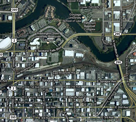 This area (south of the Spokane River, east of Division, north of 2nd Avenue, and west of Sprague Way and the Hamilton overpass) is part of Spokane's University District. The effort was conducted to survey the residents' attitudes about the proposed pedestrian overpass between the Riverpoint Campus and the warehouse district. But, additionally, the survey's observations can serve as a baseline for any changes that occur due to investments made in the area. That is, we're taking the "before" picture. The results will be used to help inform the health district in their recommendation to the City of Spokane.
Wondering why this is being conducted by the Health District? The Health District has a Physical Activity and Nutrition program which, in part, encourages pedestrian and biking activity. The Health District is performing this research in order to estimate what kind of change in physical activity is likely to occur as a result in a change in the pedestrian infrastructure.
There was only about a dozen of us, but we did survey the entire area in just a couple hours. I was working with Mohammed Aly, another graduate student in the urban and regional planning department at EWU. The area we were assigned was the southeastern portion, mostly auto-oriented businesses, self-storage, some office spaces, and, from what we noted, one residence. We walked up and down the streets wearing orange vests assessing the prevalence of vandalism in the area, including graffiti and broken windows.
I think there's something very useful in having people actually take a look at their environment. It's difficult to change something unless you take the time to truly take a look at it. What I would have enjoyed in addition to this is to go with one of the residents and business owners (or more) to allow them to point out what they think is important. We did meet a gentleman there who certainly seemed engaged and willing to share his community with us, and I suspect it's not any different in many other places, too. In an ideal planning activity, you'd want to include that kind of data to ensure that you're not trying to solve a problem that doesn't exist in the minds of the people who are involved.
It was an excellent experience, one I'm looking forward to repeating, especially if the weather is as nice as it was yesterday!
For more information on the pedestrian bridge, and many other transportation- and transit-related projects in the downtown area, you are invited to an open house from 4:30 PM to 7 PM on Tuesday, March 29, at the Spokane City Council Chambers on the lower level of Spokane City Hall, 808 W Spokane Falls Blvd.
Optional Reading List - Winter 2011
As part of a continuing series of recommended readings from the professors and students of Eastern Washington University's Urban and Regional Planning program, here is your latest optional reading list!
The works, and my understanding of them, are below. If the descriptions are inaccurate, then it's because I misunderstood and I'd appreciate a heads-up!
A Sand County Almanac, by Aldo Leopold, nonfiction recommended by Dr. Zovanyi. In a beautifully written series of essays about his observations of nature, Leopold expresses the importance of preserving the environment and his concept of the Land Ethic.
Our Ecological Footprint, by Williams E. Rees and Mathis Wackernagel, nonfiction recommended by Dr. Zovanyi. This is the book that defines the concept of our "footprint" and argues that our combined footprint is exceeding the planet's capacity to renew itself.
The Last Landscape, nonfiction by William H. Whyte recommended by Dr. Hurand. This book, published more than four decades ago, urges Americans to make better use of space. While others noted its importance at the time (Jane Jacobs called it "an excellent book"), it is relevant to today's sprawl-oriented nation searching for an alternative.
Ishmael, by Daniel Quinn, fiction recommended by Dr. Zovanyi. I reviewed this after I read it a few weeks back. It's a story about Mother Culture, and a challenge presented to her by a telepathic gorilla. No, it's not science fiction: it's a survey of human history and human present, and asks us to consider what the human future is going to be.
Integral Urbanism, by Nan Ellin, nonfiction recommended by Dr. Winchell. It documents the transition from mechanical, rigid modernistic architecture to humanist post-modern architecture and its application to New Urbanism.
Beyond Growth: The Economics of Sustainable Development, nonfiction by Herman Daly, recommended by Dr. Zovanyi. This is an economic treatise recognizing the upcoming change to the very nature of economics when the irrational assumption of unending growth is finally overthrown.
House Form and Culture, nonfiction by Amos Rapoport and recommended by Dr. Hurand. Amos Rapoport is an environmental psychology researcher, studying the complex interplay between how people change their environment and how the environment affects human behavior. In this work, he discusses the connection between the culture of a people and the kind of housing they construct.
The Levittowners, nonfiction by Herbert Gans and recommended by Dr. Hurand. The first infamous suburban development is studied to determine what kind of culture was being created in an extended area of mass-produced, identical houses.
The Big Burn: Teddy Roosevelt and the Fire that Saved America, nonfiction by Timothy Egan, recommended by, well, everyone. Just over 100 years ago, there was a spectacular fire here in the northwest in which an area the size of Connecticut burned in a weekend. The flames moved faster than a horse at full gallop. The frontier was officially closed by this point in American history, and Roosevelt was trying to ignite a tradition to conserve this nation's wild spaces. This work tells the story of the fire, and how it changed the way America treats its public lands.
Thank you, IES-APA Part Deux
Last quarter I wrote about a couple of the books that I purchased for classes using the money I was awarded for a short essay I wrote entitled "The Purpose of Urban and Regional Planning." The $500 award was more than necessary to purchase my books for last quarter, so the remaining funds were used to purchase books this quarter.
The first book I purchased is the fifth edition of Urban Land Use Planning by Berke, Godschalk, Kaiser, and Rodriguez. (Now that I'm typing this out, I recognize Kaiser and Godschalk from an essay I read during my first quarter, "Twentieth Century Land Use Planning," which on my list of articles to review on this blog.) I purchased the book for PLAN 440 (Land Use Planning). Flipping through the pages I see that its pages are highly colorful with the pictures and graphics you'd expect from an undergraduate textbook.
The second book is the second edition of Understanding Your Economy by McLean and Voytek. This is the required textbook for PLAN 504 (Planning Methods II). It is published by the American Planning Association and conforms to the format that I've learned to expect from the APA, even in fonts and horizontal rules. This one, however, is beginning to show its age, as the exhibits are sometimes blurry or indistinct. And, certainly, the data is elderly and I noticed it is using SIC codes (valid from the 1930's) rather than NAICS (established in 1997). This is understandable as this second edition was first published in 1992.
I have one other class this quarter, PLAN 460 (Urban Design), but the bookstore is unaware of any textbooks which may be necessary. But, even if there were a book for it, the $500 ran out with the purchase of the two books above. Still, that's a total of five books which didn't come out of this poor student's wallet, and that is greatly appreciated!
Separated Bike Lanes
One topic often addressed by this blog is that of bike lanes due to their importance in creating complete streets to increase transportation choices, improve air quality, and decrease our dependence on oil. But, it also gets significant attention here because it is the subject of significant controversy.
One of the ways that a safe, welcoming bike lane can be provided to the public is by separating the bike path from the auto lanes. (Want to see the study on separated bike lane safety? Here it is from Injury Prevention.) These separated bike lanes not only make clear the place where bicycle riders are to be, but also exclude dangerous elements, such as moving automobiles or stationary ones with their doors suddenly opening in the path of a biker ("dooring"). And, yes, it does happen, and it can be fatal.
Spokane has a separated bike trail: the Centennial Trail. However, that's more of a bicycle highway, which allows people to travel long distances undisturbed, but also fails to successfully deliver bike riders to their destinations without, as Danish architect and infrastructure consultant Jan Gehl says, "[letting] people fend for themselves once they reach the city." Nevertheless, it's a commendable achievement that we should build upon.
The true usefulness of separated bike paths is when they're permitted to enter the core of the community. A local example of that is the bike system in Liberty Lake. It connects to the Centennial Trail, consists of a number of interconnected trails (though, not all are separated from the road), and many are surrounded by trees and grass. But, these are not urban trails as would be necessary in downtown Spokane or anywhere else where they'd need to be shoehorned in. So what do we do in that situation?
Well, it's pretty congested in New York City:
The first separated bike lane in NYC was proposed in 2007, and its cross-section is below. In this case, a 15-foot wide planted area was inserted into the right-of-way to come between the moving automobiles and the bicyclists. The planted area also includes parking while protecting the bikers from being doored.

The video above did note that there are places where solid barriers would be inappropriate, such as when emergency or delivery vehicles must approach the curb. In that case, a double rolled-curb barrier such as the one displayed here (thank you to StreetsWiki) 
Coming back to the Pacific Northwest, the current issue of Planning Magazine brings the story of Vancouver, British Columbia's newest experiment in separated bike paths. While separated bike paths were available along the water's edge, last summer brought a proposal to separate the bike path on Hornby Street, penetrating into downtown.
Could Spokane do the same thing? It does present challenges. It is more complex than laying down stripes and it does need to be designed into the physicality of the road. Second Avenue, for instance, would need a concrete strip of some kind in order to move the parking meters away from the sidewalk. However, for much of Spokane region, the roads are very wide, and a few feet for a concrete strip would be easy to accommodate. Plowing would become impossible in the bike lanes in that case, but the city doesn't sufficiently maintain the bike lanes in those situations, anyway. Indeed, you might be able to pitch it as an alternative to piling up snow in the middle of the road during major storms.
As always, the character of the neighborhood and the people's transportation demands will be key to deciding what form a transportation asset will take. But, no matter what you may think about them in general, building separated bike lanes is a valid alternative, and no transportation plan proposal should be presented to the public without it.
Planning Magazine
One of the benefits of being a member of the American Planning Association is receipt of its monthly magazine, "Planning." Members have access online as well. (That link is available to anyone, though the links on that page are not normally available. Having said that, I do remember that the APA gave access to certain articles on a case-by-case basis.)
Planning Magazine is fascinating for a couple of reasons. Of course, you must know by now that I find planning fascinating in general, otherwise I wouldn't be making the $50,000 bet in the form of student loans and years of my life to get a degree in it. But, also, it is fascinating because of its breadth of field. (This is also a criticism. Remind me to tell you about Aaron Wildavsky's classic article "If Planning is Everything, Maybe It's Nothing" someday.) The point is, if you can't find an interesting topic in the planning field, you're probably not trying very hard.
So, what's the point of this blog entry, then? Simply, to let you know that I'll be reviewing some topics brought up by Planning Magazine on occasion, so you'll be able to see just how broad planning is. Also, you'll find that many of the topics we struggle with in Spokane are being faced in other places--and they're doing something about it! Maybe we can, too.
Jefferson Elementary Update
Spokane Public Schools has released plans for the construction of the new Jefferson Elementary School. The presentation provided at the recent open house has been posted on its web site.
This new site has been the subject of considerable controversy. Proponents of the location change pointed to a survey conducted by the district in favor of the move, preservation of the use of the old elementary building, and a $4 million cost savings. Opponents delivered 900 signatures against the move citing increased traffic and harming residential property values.
According to the Spokesman-Review, the design of the site retains the old stand of trees which was feared to be lost as a result of the construction. The new plan actually increases the number of trees on the site along both 37th Avenue and Manito Boulevard.
There will be additional open houses this year to show progress on the project. The first will be on March 31, before the design presentation to the board on April 13. The second will be on September 29, after design development is complete. The project is anticipated to go to bid next winter, with construction occurring throughout 2012 and into 2013, just in time for the 2013-2014 school year.
Triumph of the City
Harvard economist Edward Glaeser was a guest on The Daily Show. His book, Triumph of the City: How Our Greatest Invention Makes Us Richer, Smarter, Greener, Healthier, and Happier is the subject of the segment. Just as Lewis Mumford observes in his classic "The City in History," Glaeser states that the proximity of people within cities allow interactions that increase our knowledge. In modern times, life expectancy is actually greater in cities due to better lifestyle habits, such as walking, and due to investments in key health technologies such as the provision of clean water. Additionally, cities are economically stronger places.
Despite these advantages, Glaeser points out anti-urban federal policies such as the home mortgage interest deduction ("we make a fetish of home ownership in this country") and higher highway subsidies in suburban areas ("[funded] two to one in the lowest density areas").
Obviously, no place or form is perfect. Every neighborhood must choose its own best solution. But I believe that Glaeser is setting up an important point: if cities are so bad, why do we subsidize the suburbs?
h/t to Studio Cascade for bringing this to my attention!
Subscribe to:
Posts (Atom)